
Rocourt topographic map
Interactive map
Click on the map to display elevation.
About this map
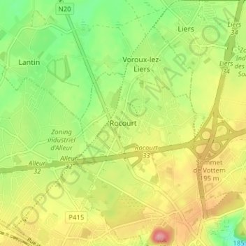
Name: Rocourt topographic map, elevation, terrain.
Location: Rocourt, Liège, Wallonie, 4000, Belgique (50.65804 5.52762 50.69804 5.56762)
Average elevation: 173 m
Minimum elevation: 124 m
Maximum elevation: 227 m
Other topographic maps
Click on a map to view its topography, its elevation and its terrain.
Jupille-sur-Meuse
Belgique > Liège > Liège > Liège
Jupille-sur-Meuse, Liège, Wallonie, 4000, Belgique
Average elevation: 133 m