
остров Веры topographic map
Interactive map
Click on the map to display elevation.
About this map
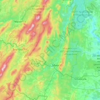
Name: остров Веры topographic map, elevation, terrain.
Average elevation: 445 m
Minimum elevation: 254 m
Maximum elevation: 1,167 m
Other topographic maps
Click on a map to view its topography, its elevation and its terrain.
Chelyabinsk
Russia > Chelyabinsk Oblast > Chelyabinsk
Chelyabinsk, Sovetskiy rayon, Chelyabinsk, Chelyabinsk Oblast, Ural Federal District, Russia
Average elevation: 230 m
Verhniy Ufaley
Russia > Chelyabinsk Oblast > Verhniy Ufaley
Verhniy Ufaley, Verkhny Ufaley, Chelyabinsk Oblast, Ural Federal District, 456800, Russia
Average elevation: 404 m
Verhniy Ufaley
Russia > Chelyabinsk Oblast > Verhniy Ufaley
Verhniy Ufaley, Verkhny Ufaley, Chelyabinsk Oblast, Ural Federal District, 456800, Russia
Average elevation: 393 m