
Goma topographic map
Interactive map
Click on the map to display elevation.
Goma
Köppen-Geiger climate classification system classifies Goma's climate as a tropical savanna climate (Aw). Goma is much milder than most climates of its type due to the city's high altitude, and sees warm days and pleasant nights year-round.
About this map
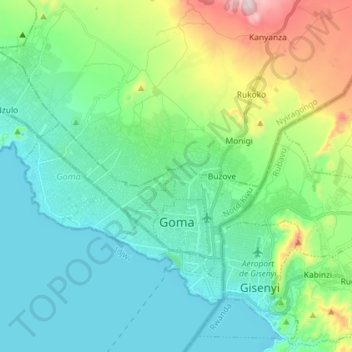
Name: Goma topographic map, elevation, terrain.
Location: Goma, North Kivu, Democratic Republic of the Congo (-1.70047 29.11525 -1.59511 29.26008)
Average elevation: 1,613 m
Minimum elevation: 1,454 m
Maximum elevation: 2,138 m
Other topographic maps
Click on a map to view its topography, its elevation and its terrain.