
Thank you for supporting this site ❤️
Make a donation
Make a donation
Gear up for your next adventure:
As an Amazon Associate, this site earns from qualifying purchases at no extra cost to you.
Cordella topographic map
Click on the map to display elevation.
Thank you for supporting this site ❤️
Make a donation
Make a donation
Gear up for your next adventure:
As an Amazon Associate, this site earns from qualifying purchases at no extra cost to you.
About this map
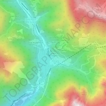
Name: Cordella topographic map, elevation, terrain.
Location: Cordella, Masarè, Alleghe, Belluno, Veneto, 32022, Italia (46.38953 12.00010 46.42953 12.04010)
Average elevation: 1,363 m
Minimum elevation: 845 m
Maximum elevation: 2,180 m
Thank you for supporting this site ❤️
Make a donation
Make a donation
Gear up for your next adventure:
As an Amazon Associate, this site earns from qualifying purchases at no extra cost to you.