
La Ville topographic map
Interactive map
Click on the map to display elevation.
About this map
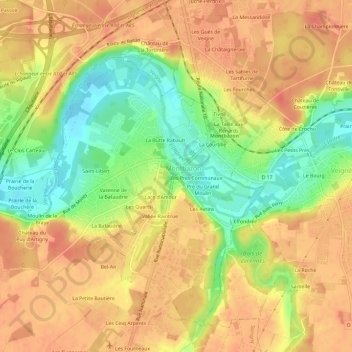
Name: La Ville topographic map, elevation, terrain.
Average elevation: 78 m
Minimum elevation: 46 m
Maximum elevation: 97 m
Other topographic maps
Click on a map to view its topography, its elevation and its terrain.
La Farte
France > Centre-Val de Loire > Indre-et-Loire > Montbazon
La Farte, Montbazon, Tours, Indre-et-Loire, Centre-Val de Loire, France métropolitaine, 37250, France
Average elevation: 78 m
Vallée Raintrue
France > Centre-Val de Loire > Indre-et-Loire > Montbazon
Vallée Raintrue, Montbazon, Tours, Indre-et-Loire, Centre-Val de Loire, France métropolitaine, 37250, France
Average elevation: 78 m
Saint-Libert
France > Centre-Val de Loire > Indre-et-Loire > Montbazon
Saint-Libert, Montbazon, Tours, Indre-et-Loire, Centre-Val de Loire, France métropolitaine, 37250, France
Average elevation: 78 m
Château d'Artigny
France > Centre-Val de Loire > Indre-et-Loire > Montbazon > Moulin de la Braye
Château d'Artigny, Rue de Monts, Terrasse du Parc, Moulin de la Braye, Montbazon, Arrondissement de Tours, Indre-et-Loire, Centre-Val de Loire, France métropolitaine, 37250, France
Average elevation: 76 m