
Make a donation
Gear up for your next adventure:
As an Amazon Associate, this site earns from qualifying purchases at no extra cost to you.
Kamberg topographic map
Click on the map to display elevation.
Make a donation
Gear up for your next adventure:
As an Amazon Associate, this site earns from qualifying purchases at no extra cost to you.
About this map
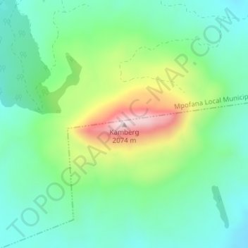
Name: Kamberg topographic map, elevation, terrain.
Average elevation: 1,768 m
Minimum elevation: 1,629 m
Maximum elevation: 2,085 m
Make a donation
Gear up for your next adventure:
As an Amazon Associate, this site earns from qualifying purchases at no extra cost to you.
Other topographic maps
Click on a map to view its topography, its elevation and its terrain.
uMngeni River
South Africa > KwaZulu-Natal > uMgungundlovu District Municipality > uMgeni Local Municipality > Howick
Average elevation: 1,036 m
uMngeni
South Africa > KwaZulu-Natal > uMgungundlovu District Municipality > uMgeni Local Municipality
Average elevation: 1,467 m
Mpofana
South Africa > KwaZulu-Natal > uMgungundlovu District Municipality > uMgeni Local Municipality
Average elevation: 1,332 m
uMngeni River
South Africa > KwaZulu-Natal > uMgungundlovu District Municipality > uMgeni Local Municipality > Howick
Average elevation: 1,041 m
Make a donation
Gear up for your next adventure:
As an Amazon Associate, this site earns from qualifying purchases at no extra cost to you.
uMngeni
South Africa > KwaZulu-Natal > uMgungundlovu District Municipality > uMgeni Local Municipality
Average elevation: 1,083 m
Lions River
South Africa > KwaZulu-Natal > uMgungundlovu District Municipality > uMgeni Local Municipality
Average elevation: 1,161 m