
Dusseldorf topographic map
Interactive map
Click on the map to display elevation.
Dusseldorf
The Archbishop of Cologne's forces were wiped out by the forces of the count of Berg who were supported by citizens and farmers of Cologne and Düsseldorf, paving the way for Düsseldorf's elevation to city status, which is commemorated today by a monument on the Burgplatz. The custom of turning cartwheels is credited to the children of Düsseldorf. There are variations of the origin of the cartwheeling children. Today the symbol (Der Radschläger) represents the story and every year the Düsseldorfers celebrate by having a cartwheeling contest. After this battle the relationship between the four cities deteriorated, because they were commercial rivals; it is often said that there is a kind of hostility between the citizens of Cologne and Düsseldorf. Today, it finds its expression mainly in a humorous form (especially during the Rhineland Karneval) and in sports.
About this map
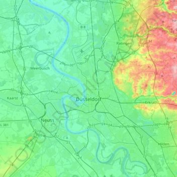
Name: Dusseldorf topographic map, elevation, terrain.
Location: Dusseldorf, North Rhine-Westphalia, Germany (51.12437 6.68881 51.35249 6.93993)
Average elevation: 54 m
Minimum elevation: 17 m
Maximum elevation: 188 m
Other topographic maps
Click on a map to view its topography, its elevation and its terrain.
Siedlinghausen
Germany > North Rhine-Westphalia > Hochsauerlandkreis > Winterberg
Average elevation: 563 m