
Make a donation
Gear up for your next adventure:
As an Amazon Associate, this site earns from qualifying purchases at no extra cost to you.
Warth topographic map
Click on the map to display elevation.
Make a donation
Gear up for your next adventure:
As an Amazon Associate, this site earns from qualifying purchases at no extra cost to you.
Warth
Warth liegt im Bezirk Bregenz etwa 42 km südöstlich des Bodensees auf 1495 m Höhe am Tannberg. Dort befindet sich die Ortschaft nur etwas südlich des Haldenwanger Ecks. Mit der offiziellen Seehöhe von 1495 m ü. A. ist Warth die höchstgelegene Vorarlberger Gemeinde. Warth ist die östlichste Gemeinde, die noch geografisch und geschichtlich der Region Bregenzerwald zugerechnet wird, touristisch zählt Warth aber zur Arlbergregion und liegt geografisch bereits im Lechtal. Alle anderen Bregenzerwäldergemeinden liegen hingegen im Tal der Bregenzer Ach oder einem der Seitentäler der Bregenzer Ach.
Make a donation
Gear up for your next adventure:
As an Amazon Associate, this site earns from qualifying purchases at no extra cost to you.
About this map
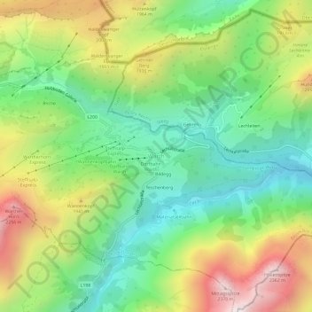
Name: Warth topographic map, elevation, terrain.
Average elevation: 1,703 m
Minimum elevation: 1,271 m
Maximum elevation: 2,383 m
Make a donation
Gear up for your next adventure:
As an Amazon Associate, this site earns from qualifying purchases at no extra cost to you.