
San Juan County topographic map
Interactive map
Click on the map to display elevation.
San Juan County
San Juan County is a cluster of more than 400 islands and rocks with elevations above mean high tide. 134 of these islands and rocks are named. The county has a rugged, rocky shoreline and several mountains. The highest point in the county is Mount Constitution on Orcas Island at 2,407 feet (734 m) above sea level.
About this map
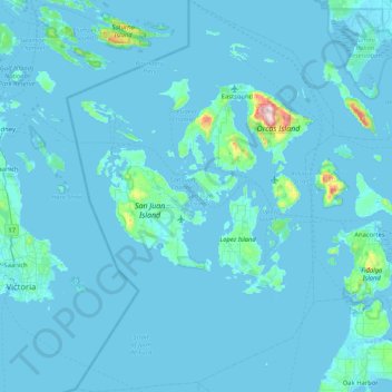
Name: San Juan County topographic map, elevation, terrain.
Location: San Juan County, Washington, United States (48.28007 -123.26789 48.83122 -122.70154)
Average elevation: 20 m
Minimum elevation: -3 m
Maximum elevation: 711 m
Other topographic maps
Click on a map to view its topography, its elevation and its terrain.
Mount Rainier
United States > Washington > Pierce County
Mount Rainier (/reɪˈnɪər/ ray-NEER), also known as Tahoma, is a large active stratovolcano in the Cascade Range of the Pacific Northwest in the United States. The mountain is located in Mount Rainier National Park about 59 miles (95 km) south-southeast of Seattle. With a summit elevation of 14,399.6 ft…
Average elevation: 3,912 m
Mount Olympus
United States > Washington > Jefferson County
With notable local relief, Mount Olympus ascends over 2,100 m (6,900 ft) from the 293 m (961 ft) elevation confluence of the Hoh River with Glacier Creek in only 8.8 km (5.5 mi). Mount Olympus has 2,386 m (7,828 ft) of prominence, ranking 5th in the state of Washington.
Average elevation: 1,934 m