
Make a donation
Gear up for your next adventure:
As an Amazon Associate, this site earns from qualifying purchases at no extra cost to you.
Heilbronn topographic map
Click on the map to display elevation.
Make a donation
Gear up for your next adventure:
As an Amazon Associate, this site earns from qualifying purchases at no extra cost to you.
About this map
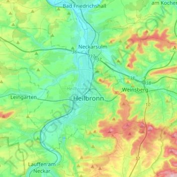
Name: Heilbronn topographic map, elevation, terrain.
Location: Heilbronn, Baden-Württemberg, Germany (49.09289 9.04461 49.20973 9.30197)
Average elevation: 220 m
Minimum elevation: 144 m
Maximum elevation: 415 m
Make a donation
Gear up for your next adventure:
As an Amazon Associate, this site earns from qualifying purchases at no extra cost to you.
Other topographic maps
Click on a map to view its topography, its elevation and its terrain.
Lauterbad
Germany > Baden-Württemberg > Landkreis Freudenstadt > Freudenstadt > Dietersweiler
Average elevation: 702 m
Make a donation
Gear up for your next adventure:
As an Amazon Associate, this site earns from qualifying purchases at no extra cost to you.
Lützenhardt
Germany > Baden-Württemberg > Landkreis Freudenstadt > Waldachtal
Average elevation: 615 m
Hollerbach
Germany > Baden-Württemberg > Neckar-Odenwald-Kreis > Buchen (Odenwald)
Average elevation: 395 m
Make a donation
Gear up for your next adventure:
As an Amazon Associate, this site earns from qualifying purchases at no extra cost to you.