Geolocate

Meurthe-et-Moselle topographic map

Interactive map

Click on the map to display elevation.

About this map

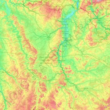
Name: Meurthe-et-Moselle topographic map, elevation, terrain.

Location: Meurthe-et-Moselle, Grand Est, Metropolitan France, France (48.34890 5.42607 49.56334 7.12322)

Average elevation: 275 m

Minimum elevation: 141 m

Maximum elevation: 614 m

Other topographic maps

Click on a map to view its topography, its elevation and its terrain.

Chemin du Clos

France > Grand Est > Aube > Avant-lès-Marcilly

Average elevation: 119 m

Portions

France > Grand Est > Moselle > Burlioncourt

Average elevation: 234 m

Strasbourg

France > Grand Est > Bas-Rhin > Strasbourg

Average elevation: 154 m

La Chapelle

France > Grand Est > La Chapelle

Average elevation: 171 m

L Ouche

France > Grand Est > Pouy-sur-Vannes

Average elevation: 168 m

Roche des Fées

France > Grand Est > Neubois

Average elevation: 637 m

Le Bout d'en Haut

France > Grand Est > Ardennes > Gué-d'Hossus

Average elevation: 353 m

Richat

France > Grand Est > Ardennes > Fromelennes

Average elevation: 165 m