Geolocate

Binstead topographic map

Click on the map to display elevation.

About this map

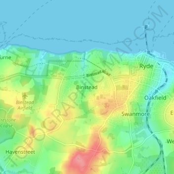
Name: Binstead topographic map, elevation, terrain.

Location: Binstead, Isle of Wight, England, PO33 3QZ, United Kingdom (50.70508 -1.20202 50.74508 -1.16202)

Average elevation: 23 m

Minimum elevation: 0 m

Maximum elevation: 79 m

Other topographic maps

Click on a map to view its topography, its elevation and its terrain.

Wootton Bridge

United Kingdom > England > Isle of Wight

Average elevation: 26 m

Gear up for your next adventure:

🛶Inflatable Touring Kayaks - Explore Irish loughs and coastal topography
⛷️Mountain Sports Accessories - Gear for high intensity outdoor sports
🧤Touchscreen Glove Liners - Use your mapping app without freezing your hands
🔦High-Lumen Headlamps - Hands-free lighting for early starts or late finishes
🪑Compact Camp Chairs - Comfortable seating after a long day of mapping

As an Amazon Associate, this site earns from qualifying purchases at no extra cost to you.