
Thank you for supporting this site ❤️
Make a donation
Make a donation
Gear up for your next adventure:
As an Amazon Associate, this site earns from qualifying purchases at no extra cost to you.
Kanena topographic map
Click on the map to display elevation.
Thank you for supporting this site ❤️
Make a donation
Make a donation
Gear up for your next adventure:
As an Amazon Associate, this site earns from qualifying purchases at no extra cost to you.
About this map
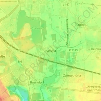
Name: Kanena topographic map, elevation, terrain.
Location: Kanena, Halle (Saale), Sachsen-Anhalt, 06116, Deutschland (51.43718 12.01711 51.47718 12.05711)
Average elevation: 97 m
Minimum elevation: 74 m
Maximum elevation: 118 m
Thank you for supporting this site ❤️
Make a donation
Make a donation
Gear up for your next adventure:
As an Amazon Associate, this site earns from qualifying purchases at no extra cost to you.