Geolocate

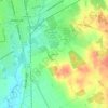
Cleburne topographic map

Click on the map to display elevation.

About this map

Name: Cleburne topographic map, elevation, terrain.

Location: Cleburne, Johnson County, Texas, United States (32.27795 -97.54567 32.44740 -97.34621)

Average elevation: 254 m

Minimum elevation: 208 m

Maximum elevation: 297 m

Other topographic maps

Click on a map to view its topography, its elevation and its terrain.

Highland

United States > Texas > Johnson County

Average elevation: 198 m

Turkey Peak

United States > Texas > Johnson County > Burleson

Average elevation: 237 m

Oak Hill

United States > Texas > Johnson County > Cleburne

Average elevation: 240 m

Gear up for your next adventure:

👣Waterproof Leg Gaiters - Keep bog water and debris out of your boots
🔋Lithium Batteries - Best performance for digital devices in cold weather
🩻Outdoor Health Essentials - Necessary health items for hikes
🎒Surveyor High-Vis Vests - Multi-pocket safety vests for field professionals
🧯Portable Extinguishers - Safety tools for campfires

As an Amazon Associate, this site earns from qualifying purchases at no extra cost to you.