
Make a donation
Gear up for your next adventure:
As an Amazon Associate, this site earns from qualifying purchases at no extra cost to you.
Flower Ridge topographic map
Click on the map to display elevation.
Make a donation
Gear up for your next adventure:
As an Amazon Associate, this site earns from qualifying purchases at no extra cost to you.
About this map
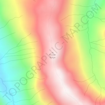
Name: Flower Ridge topographic map, elevation, terrain.
Average elevation: 1,095 m
Minimum elevation: 549 m
Maximum elevation: 1,533 m
Make a donation
Gear up for your next adventure:
As an Amazon Associate, this site earns from qualifying purchases at no extra cost to you.
Other topographic maps
Click on a map to view its topography, its elevation and its terrain.
Oyster River
Canada > British Columbia > Strathcona Regional District > Area D (Oyster Bay/Buttle Lake) > Oyster River
Average elevation: 24 m
Upper Campbell Lake
Canada > British Columbia > Strathcona Regional District > Area D (Oyster Bay/Buttle Lake)
Average elevation: 632 m
Moving Glacier
Canada > British Columbia > Strathcona Regional District > Area D (Oyster Bay/Buttle Lake)
Average elevation: 1,539 m
Arnica Lake
Canada > British Columbia > Strathcona Regional District > Area D (Oyster Bay/Buttle Lake)
Average elevation: 1,180 m
Make a donation
Gear up for your next adventure:
As an Amazon Associate, this site earns from qualifying purchases at no extra cost to you.