
Make a donation
Gear up for your next adventure:
As an Amazon Associate, this site earns from qualifying purchases at no extra cost to you.
Aqueduc du Loing topographic map
Click on the map to display elevation.
Make a donation
Gear up for your next adventure:
As an Amazon Associate, this site earns from qualifying purchases at no extra cost to you.
About this map
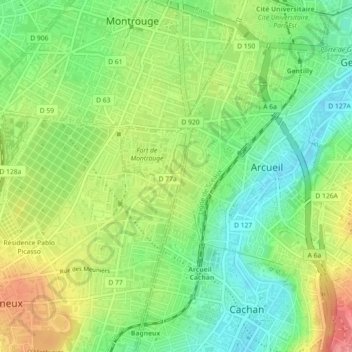
Name: Aqueduc du Loing topographic map, elevation, terrain.
Average elevation: 77 m
Minimum elevation: 42 m
Maximum elevation: 125 m
Make a donation
Gear up for your next adventure:
As an Amazon Associate, this site earns from qualifying purchases at no extra cost to you.
Other topographic maps
Click on a map to view its topography, its elevation and its terrain.
Paris
Au-delà le terrain s’élève vers le col de la Chapelle à l’est, la butte Montmartre au centre et, en pente douce, vers le large col d’une altitude de 40 mètres à 50 mètres entre cette butte et la colline de Chaillot. Passé ce col, la pente très faible en direction de la Seine à Levallois-Perret…
Average elevation: 75 m