
Essex County topographic map
Interactive map
Click on the map to display elevation.
About this map
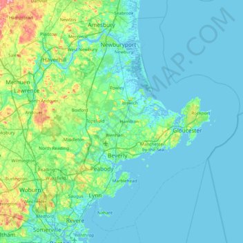
Name: Essex County topographic map, elevation, terrain.
Location: Essex County, Massachusetts, Verenigde Staten van Amerika (42.38429 -71.25619 42.88678 -70.49901)
Average elevation: 25 m
Minimum elevation: -5 m
Maximum elevation: 179 m
Other topographic maps
Click on a map to view its topography, its elevation and its terrain.
Thermopylae
Verenigde Staten van Amerika > Massachusetts > Holyoke > Thermopylae
Thermopylae, Holyoke, Hampshire, Massachusetts, 01075, Verenigde Staten van Amerika
Average elevation: 76 m
Middlesex County
Verenigde Staten van Amerika > Massachusetts
Middlesex County, Massachusetts, Verenigde Staten van Amerika
Average elevation: 80 m