
Make a donation
Gear up for your next adventure:
As an Amazon Associate, this site earns from qualifying purchases at no extra cost to you.
Leinfelden topographic map
Click on the map to display elevation.
Make a donation
Gear up for your next adventure:
As an Amazon Associate, this site earns from qualifying purchases at no extra cost to you.
About this map
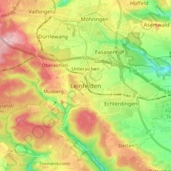
Name: Leinfelden topographic map, elevation, terrain.
Average elevation: 431 m
Minimum elevation: 347 m
Maximum elevation: 526 m
Make a donation
Gear up for your next adventure:
As an Amazon Associate, this site earns from qualifying purchases at no extra cost to you.
Other topographic maps
Click on a map to view its topography, its elevation and its terrain.
Make a donation
Gear up for your next adventure:
As an Amazon Associate, this site earns from qualifying purchases at no extra cost to you.
Make a donation
Gear up for your next adventure:
As an Amazon Associate, this site earns from qualifying purchases at no extra cost to you.
Lichtenwald
Germany > Baden-Württemberg > Landkreis Esslingen
The district of Hegenlohe lies on the wooded eastern slope (also called Heuberg by locals) of the Reichenbach valley and, like Thomashardt situated on the high ridge, is surrounded by the mixed forests of the Schurwald. The municipal area ranges from 342 to 480 meters in elevation.
Average elevation: 426 m
Make a donation
Gear up for your next adventure:
As an Amazon Associate, this site earns from qualifying purchases at no extra cost to you.
Make a donation
Gear up for your next adventure:
As an Amazon Associate, this site earns from qualifying purchases at no extra cost to you.
Make a donation
Gear up for your next adventure:
As an Amazon Associate, this site earns from qualifying purchases at no extra cost to you.
Ruine Reußenstein
Germany > Baden-Württemberg > Landkreis Esslingen > Neidlingen
Average elevation: 675 m