
Drogheda Poor Law Union 1885 topographic map
Interactive map
Click on the map to display elevation.
About this map
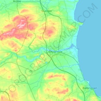
Name: Drogheda Poor Law Union 1885 topographic map, elevation, terrain.
Location: Drogheda Poor Law Union 1885, County Louth, Leinster, Ireland (53.57186 -6.52720 53.86234 -6.21291)
Average elevation: 53 m
Minimum elevation: -1 m
Maximum elevation: 249 m
County Louth trails, hiking, mountain biking, running and outdoor activities
Other topographic maps
Click on a map to view its topography, its elevation and its terrain.