
Make a donation
Gear up for your next adventure:
As an Amazon Associate, this site earns from qualifying purchases at no extra cost to you.
Portage topographic map
Click on the map to display elevation.
Make a donation
Gear up for your next adventure:
As an Amazon Associate, this site earns from qualifying purchases at no extra cost to you.
About this map
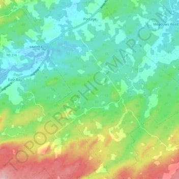
Name: Portage topographic map, elevation, terrain.
Average elevation: 57 m
Minimum elevation: -1 m
Maximum elevation: 181 m
Make a donation
Gear up for your next adventure:
As an Amazon Associate, this site earns from qualifying purchases at no extra cost to you.
Other topographic maps
Click on a map to view its topography, its elevation and its terrain.
Wentworth Park
Canada > Nova Scotia > Cape Breton Regional Municipality > Sydney
Average elevation: 16 m
Sangaree Island
Canada > Nova Scotia > Cape Breton Regional Municipality > Albert Bridge
Average elevation: 34 m
Morley Bay
Canada > Nova Scotia > Cape Breton Regional Municipality > Albert Bridge
Average elevation: 6 m