
Make a donation
Gear up for your next adventure:
As an Amazon Associate, this site earns from qualifying purchases at no extra cost to you.
Reute topographic map
Click on the map to display elevation.
Make a donation
Gear up for your next adventure:
As an Amazon Associate, this site earns from qualifying purchases at no extra cost to you.
Reute
Reute (häufig auch Emsreute, Emser Reute, Hohenems-Reute oder von den Einwohnern Emsner Rütte genannt) ist ein Ortsteil der österreichischen Stadt Hohenems im Bundesland Vorarlberg. Der Ortsteil liegt auf etwa 650 m ü. A. Höhe am östlichen Berghang über dem Stadtkern von Hohenems. Mit einer Einwohnerzahl von 588 Einwohnern machten die Bewohner des Ortsteils bei der Volkszählung im Jahr 2001 etwa 4,2 Prozent der Hohenemser Gesamtbevölkerung aus.
Make a donation
Gear up for your next adventure:
As an Amazon Associate, this site earns from qualifying purchases at no extra cost to you.
About this map
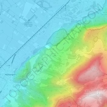
Name: Reute topographic map, elevation, terrain.
Location: Reute, Hohenems, Bezirk Dornbirn, Vorarlberg, 6845, Österreich (47.35189 9.69288 47.39189 9.73288)
Average elevation: 701 m
Minimum elevation: 407 m
Maximum elevation: 1,504 m
Make a donation
Gear up for your next adventure:
As an Amazon Associate, this site earns from qualifying purchases at no extra cost to you.