
Make a donation
Gear up for your next adventure:
As an Amazon Associate, this site earns from qualifying purchases at no extra cost to you.
Taliparamba topographic map
Click on the map to display elevation.
Make a donation
Gear up for your next adventure:
As an Amazon Associate, this site earns from qualifying purchases at no extra cost to you.
Taliparamba
Taliparamba is located at 12°03′N 75°21′E / 12.05°N 75.35°E / 12.05; 75.35. It has an average elevation of 56 metres (184 ft) above sea level. The surrounding area (including the villages of Pattuvam, Pariyaram, Kuttiyeri, Karimbam, and Koonam) features lush green fields and low rolling hills. The Kuppam and Valapattanam rivers surround the town and the Arabian Sea is only 14 kilometres (8.7 mi) to the west of the city.
Make a donation
Gear up for your next adventure:
As an Amazon Associate, this site earns from qualifying purchases at no extra cost to you.
About this map
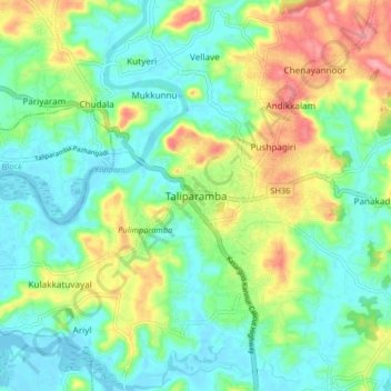
Name: Taliparamba topographic map, elevation, terrain.
Location: Taliparamba, Kannur district, Kerala, 670141, India (12.00251 75.31698 12.08251 75.39698)
Average elevation: 36 m
Minimum elevation: -2 m
Maximum elevation: 109 m
Make a donation
Gear up for your next adventure:
As an Amazon Associate, this site earns from qualifying purchases at no extra cost to you.
Other topographic maps
Click on a map to view its topography, its elevation and its terrain.