
Make a donation
Gear up for your next adventure:
As an Amazon Associate, this site earns from qualifying purchases at no extra cost to you.
Idlib topographic map
Click on the map to display elevation.
Make a donation
Gear up for your next adventure:
As an Amazon Associate, this site earns from qualifying purchases at no extra cost to you.
Idlib
Idlib (Arabic: إِدْلِب, romanized: ʾIdlib, pronounced [ʔid.lib]; also spelt Idleb or Edlib) is a city in northwestern Syria, and is the capital of the Idlib Governorate. It has an elevation of nearly 500 meters (1,600 ft) above sea level, and is 59 kilometers (37 mi) southwest of Aleppo. It is located near the border with Turkey.
Make a donation
Gear up for your next adventure:
As an Amazon Associate, this site earns from qualifying purchases at no extra cost to you.
About this map
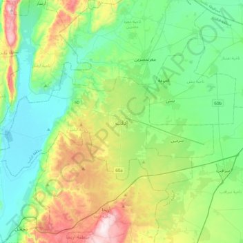
Name: Idlib topographic map, elevation, terrain.
Average elevation: 394 m
Minimum elevation: 212 m
Maximum elevation: 873 m
Make a donation
Gear up for your next adventure:
As an Amazon Associate, this site earns from qualifying purchases at no extra cost to you.
Other topographic maps
Click on a map to view its topography, its elevation and its terrain.