
Thank you for supporting this site ❤️
Make a donation
Make a donation
Gear up for your next adventure:
As an Amazon Associate, this site earns from qualifying purchases at no extra cost to you.
11 topographic map
Click on the map to display elevation.
Thank you for supporting this site ❤️
Make a donation
Make a donation
Gear up for your next adventure:
As an Amazon Associate, this site earns from qualifying purchases at no extra cost to you.
About this map
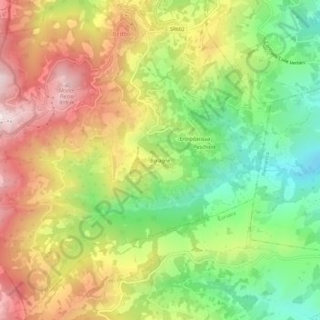
Name: 11 topographic map, elevation, terrain.
Location: 11, Boragne, Brittoli, Pescara, Abruzzo, 65010, Italy (42.28150 13.84789 42.32150 13.88789)
Average elevation: 603 m
Minimum elevation: 305 m
Maximum elevation: 934 m
Thank you for supporting this site ❤️
Make a donation
Make a donation
Gear up for your next adventure:
As an Amazon Associate, this site earns from qualifying purchases at no extra cost to you.