
Make a donation
Gear up for your next adventure:
As an Amazon Associate, this site earns from qualifying purchases at no extra cost to you.
Tibesti Mountains topographic map
Click on the map to display elevation.
Make a donation
Gear up for your next adventure:
As an Amazon Associate, this site earns from qualifying purchases at no extra cost to you.
Tibesti Mountains
Tibesti, which means "place where the mountain people live", is the domain of the Toubou people. The Toubou live mainly along the wadis, on rare oases where palm trees and limited grains grow. They harness the water that collects in gueltas, the supply of which is highly variable from year-to-year and decade-to-decade. The plateaus are used to graze livestock in the winter and harvest grain in the summer. Temperatures are high, although the altitude ensures that the range is cooler than the surrounding desert. The Toubou, who were settled in the range by the 5th century BC, adapted to these conditions and turned the range into a large natural fortress. They arrived in several waves, taking refuge in times of conflict and dispersing in times of prosperity, although not without intense internal hostility at times.
Make a donation
Gear up for your next adventure:
As an Amazon Associate, this site earns from qualifying purchases at no extra cost to you.
About this map
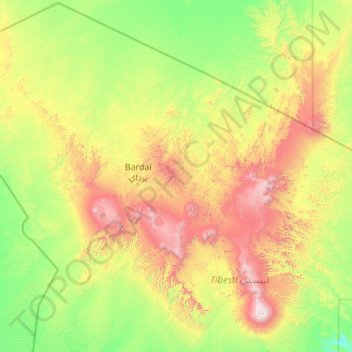
Name: Tibesti Mountains topographic map, elevation, terrain.
Location: Tibesti Mountains, Chad (19.38125 15.77950 23.48020 19.86484)
Average elevation: 955 m
Minimum elevation: 414 m
Maximum elevation: 3,353 m
Make a donation
Gear up for your next adventure:
As an Amazon Associate, this site earns from qualifying purchases at no extra cost to you.
Other topographic maps
Click on a map to view its topography, its elevation and its terrain.
Lake Chad
Lake Chad is divided into north and south parts by a shallow sill called the Great Barrier, with the bottom of the northern basin at an altitude of 275.3 m (903 ft) and the bottom of the southern basin at 278.2 m (913 ft). When the water level in the south exceeds 279 m (915 ft) above sea level, it will flow…
Average elevation: 282 m
Make a donation
Gear up for your next adventure:
As an Amazon Associate, this site earns from qualifying purchases at no extra cost to you.
Make a donation
Gear up for your next adventure:
As an Amazon Associate, this site earns from qualifying purchases at no extra cost to you.
Make a donation
Gear up for your next adventure:
As an Amazon Associate, this site earns from qualifying purchases at no extra cost to you.
Make a donation
Gear up for your next adventure:
As an Amazon Associate, this site earns from qualifying purchases at no extra cost to you.
Make a donation
Gear up for your next adventure:
As an Amazon Associate, this site earns from qualifying purchases at no extra cost to you.
Make a donation
Gear up for your next adventure:
As an Amazon Associate, this site earns from qualifying purchases at no extra cost to you.
Moundou
The first cadastral map of the town of Moundou was manufactured on 2 February 1926. Since there were not, at the time, the materials for substantial topographical surveys, the drainage pipeline of the town was facing the river in the belief that the natural inclination would head toward the river, when in…
Average elevation: 438 m
Make a donation
Gear up for your next adventure:
As an Amazon Associate, this site earns from qualifying purchases at no extra cost to you.
Make a donation
Gear up for your next adventure:
As an Amazon Associate, this site earns from qualifying purchases at no extra cost to you.
Emi Koussi
Emi Koussi (also known as Emi Koussou) is a high pyroclastic shield volcano that lies at the southeast end of the Tibesti Mountains in the central Sahara, in the northern Borkou Region of northern Chad. The highest mountain of the Sahara, the volcano is one of several in the Tibesti range, and reaches an…
Average elevation: 2,907 m
Make a donation
Gear up for your next adventure:
As an Amazon Associate, this site earns from qualifying purchases at no extra cost to you.
Make a donation
Gear up for your next adventure:
As an Amazon Associate, this site earns from qualifying purchases at no extra cost to you.
Make a donation
Gear up for your next adventure:
As an Amazon Associate, this site earns from qualifying purchases at no extra cost to you.
Make a donation
Gear up for your next adventure:
As an Amazon Associate, this site earns from qualifying purchases at no extra cost to you.
Make a donation
Gear up for your next adventure:
As an Amazon Associate, this site earns from qualifying purchases at no extra cost to you.
Make a donation
Gear up for your next adventure:
As an Amazon Associate, this site earns from qualifying purchases at no extra cost to you.
Make a donation
Gear up for your next adventure:
As an Amazon Associate, this site earns from qualifying purchases at no extra cost to you.
Make a donation
Gear up for your next adventure:
As an Amazon Associate, this site earns from qualifying purchases at no extra cost to you.
Lake Chad
Lake Chad has shrunk considerably since the 1960s, when its shoreline had an elevation of about 286 metres (938 ft) above sea level and it had an area of more than 26,000 square kilometres (10,000 sq mi), making its surface the fourth largest in Africa. An increased demand on the lake's water from the local…
Average elevation: 282 m
Make a donation
Gear up for your next adventure:
As an Amazon Associate, this site earns from qualifying purchases at no extra cost to you.
Make a donation
Gear up for your next adventure:
As an Amazon Associate, this site earns from qualifying purchases at no extra cost to you.
Make a donation
Gear up for your next adventure:
As an Amazon Associate, this site earns from qualifying purchases at no extra cost to you.
Make a donation
Gear up for your next adventure:
As an Amazon Associate, this site earns from qualifying purchases at no extra cost to you.
Make a donation
Gear up for your next adventure:
As an Amazon Associate, this site earns from qualifying purchases at no extra cost to you.
Make a donation
Gear up for your next adventure:
As an Amazon Associate, this site earns from qualifying purchases at no extra cost to you.
Make a donation
Gear up for your next adventure:
As an Amazon Associate, this site earns from qualifying purchases at no extra cost to you.
Make a donation
Gear up for your next adventure:
As an Amazon Associate, this site earns from qualifying purchases at no extra cost to you.
Make a donation
Gear up for your next adventure:
As an Amazon Associate, this site earns from qualifying purchases at no extra cost to you.