
Fuglafjørður topographic map
Interactive map
Click on the map to display elevation.
About this map
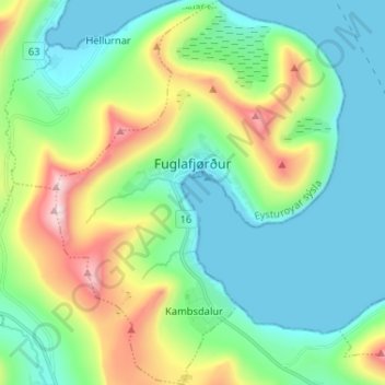
Name: Fuglafjørður topographic map, elevation, terrain.
Location: Fuglafjørður, Eysturoy region, 530, Faroe Islands (62.20902 -6.86173 62.26936 -6.76433)
Average elevation: 192 m
Minimum elevation: -9 m
Maximum elevation: 731 m
Other topographic maps
Click on a map to view its topography, its elevation and its terrain.
Eysturoy
Faroe Islands > Eysturoy region
Eysturoy, Eysturoy region, Faroe Islands
Average elevation: 162 m