
Make a donation
Gear up for your next adventure:
As an Amazon Associate, this site earns from qualifying purchases at no extra cost to you.
70 Mile House topographic map
Click on the map to display elevation.
Make a donation
Gear up for your next adventure:
As an Amazon Associate, this site earns from qualifying purchases at no extra cost to you.
About this map
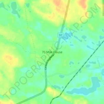
Name: 70 Mile House topographic map, elevation, terrain.
Average elevation: 1,087 m
Minimum elevation: 1,075 m
Maximum elevation: 1,104 m
Make a donation
Gear up for your next adventure:
As an Amazon Associate, this site earns from qualifying purchases at no extra cost to you.
Other topographic maps
Click on a map to view its topography, its elevation and its terrain.
Green Lake
Canada > British Columbia > Thompson-Nicola Regional District > Area E (Bonaparte Plateau)
Average elevation: 1,111 m
Riley Dam Recreation Site
Canada > British Columbia > Thompson-Nicola Regional District > Area E (Bonaparte Plateau)
Average elevation: 1,077 m
Little Green Lake
Canada > British Columbia > Thompson-Nicola Regional District > Area E (Bonaparte Plateau)
Average elevation: 1,087 m