
Phanda topographic map
Interactive map
Click on the map to display elevation.
About this map
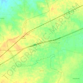
Name: Phanda topographic map, elevation, terrain.
Location: Phanda, Huzur Tahsil, Bhopal District, Madhya Pradesh, India (23.20803 77.17611 23.24822 77.23459)
Average elevation: 521 m
Minimum elevation: 503 m
Maximum elevation: 532 m
Other topographic maps
Click on a map to view its topography, its elevation and its terrain.
Bhopal
India > Madhya Pradesh > Huzur Tahsil
Bhopal, Huzur Tahsil, Bhopal District, Madhya Pradesh, 462001, India
Average elevation: 498 m
Kulan
India > Madhya Pradesh > Huzur Tahsil > Rewa
Kulan, Rewa, Huzur Tahsil, Rewa District, Madhya Pradesh, 486001, India
Average elevation: 316 m
Niga
India > Madhya Pradesh > Huzur Tahsil > Rewa
Niga, Rewa, Huzur Tahsil, Rewa District, Madhya Pradesh, 486001, India
Average elevation: 308 m
Dubi
India > Madhya Pradesh > Huzur Tahsil > Rewa
Dubi, Rewa, Huzur Tahsil, Rewa District, Madhya Pradesh, 486001, India
Average elevation: 312 m