
Make a donation
Gear up for your next adventure:
As an Amazon Associate, this site earns from qualifying purchases at no extra cost to you.
Pflersch topographic map
Click on the map to display elevation.
Make a donation
Gear up for your next adventure:
As an Amazon Associate, this site earns from qualifying purchases at no extra cost to you.
About this map
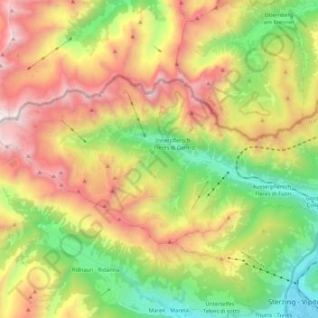
Name: Pflersch topographic map, elevation, terrain.
Average elevation: 1,905 m
Minimum elevation: 940 m
Maximum elevation: 3,149 m
Make a donation
Gear up for your next adventure:
As an Amazon Associate, this site earns from qualifying purchases at no extra cost to you.
Other topographic maps
Click on a map to view its topography, its elevation and its terrain.
Pflerschtal
Italien > Trentino-Südtirol > Bozen > Brenner
Bei einigen Bergmassiven und Gipfeln beidseits des Tals, vor allem aber bei denen auf seiner Nordseite, lagern auf dem Ötztal-Stubaier Kristallin Gesteine des sogenannten Brenner-Mesozoikums, die in der Trias abgelagert wurden. Diese überwiegend flach liegenden Sedimentgesteine sind deutlich weniger…
Average elevation: 1,891 m
Grünsee
Italien > Trentino-Südtirol > Bozen > Brenner
Der Grünsee liegt im westlichsten Teil des Pflerscher Tales auf einer Höhe von 1999 m s.l.m., westlich der Ochsenalm, von wo er auch zu erreichen ist. Er ist ein geschütztes Naturdenkmal.
Average elevation: 2,323 m
Make a donation
Gear up for your next adventure:
As an Amazon Associate, this site earns from qualifying purchases at no extra cost to you.