
Make a donation
Gear up for your next adventure:
As an Amazon Associate, this site earns from qualifying purchases at no extra cost to you.
Aravakurichi topographic map
Click on the map to display elevation.
Make a donation
Gear up for your next adventure:
As an Amazon Associate, this site earns from qualifying purchases at no extra cost to you.
Aravakurichi
Aravakurichi is located at 10°46′N 77°55′E / 10.77°N 77.92°E / 10.77; 77.92. and has an average elevation of 174 m (571 ft). The town is located off the Varnasi - Kanyakumari National Highway 7 (India). The time zone is IST (UTC+5:30).
Make a donation
Gear up for your next adventure:
As an Amazon Associate, this site earns from qualifying purchases at no extra cost to you.
About this map
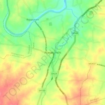
Name: Aravakurichi topographic map, elevation, terrain.
Location: Aravakurichi, Karur, Tamil Nadu, 639200, India (10.73704 77.86940 10.81704 77.94940)
Average elevation: 171 m
Minimum elevation: 142 m
Maximum elevation: 201 m
Make a donation
Gear up for your next adventure:
As an Amazon Associate, this site earns from qualifying purchases at no extra cost to you.