
Make a donation
Gear up for your next adventure:
As an Amazon Associate, this site earns from qualifying purchases at no extra cost to you.
Kleinmachnow topographic map
Click on the map to display elevation.
Make a donation
Gear up for your next adventure:
As an Amazon Associate, this site earns from qualifying purchases at no extra cost to you.
Kleinmachnow
Im Bäketal steht in der Nähe des Forsthauses eine Eiche mit einem Brusthöhenumfang von 7,63 m (2016).
Make a donation
Gear up for your next adventure:
As an Amazon Associate, this site earns from qualifying purchases at no extra cost to you.
About this map
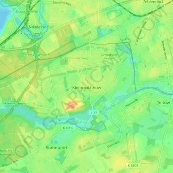
Name: Kleinmachnow topographic map, elevation, terrain.
Location: Kleinmachnow, Potsdam-Mittelmark, Brandenburg, Deutschland (52.39236 13.15779 52.42117 13.24978)
Average elevation: 44 m
Minimum elevation: 27 m
Maximum elevation: 64 m
Make a donation
Gear up for your next adventure:
As an Amazon Associate, this site earns from qualifying purchases at no extra cost to you.
Other topographic maps
Click on a map to view its topography, its elevation and its terrain.
Beetzsee
Deutschland > Brandenburg > Potsdam-Mittelmark
Beetzsee befindet sich etwa 40 Kilometer westlich der Bundeshauptstadt Berlin und im westlichen Bereich der Metropolregion Berlin/Brandenburg. Das Beetzseeufer hat je nach Wasserstand eine Höhe von durchschnittlich 28 bis 29 Meter über Normalnull. Der höchstgelegene Punkt Beetzsees ist der 89,3 Meter hohe…
Average elevation: 33 m
Make a donation
Gear up for your next adventure:
As an Amazon Associate, this site earns from qualifying purchases at no extra cost to you.
Phöben
Deutschland > Brandenburg > Potsdam-Mittelmark > Werder (Havel)
Bliesendorf mit Resau | Derwitz | Glindow mit Elisabethhöhe | Kemnitz mit Kolonie Zern | Petzow mit Löcknitz und Riegelberg | Phöben | Plötzin mit Neu Plötzin und Plessow | Töplitz mit Alt Töplitz, Eichholz, Göttin, Leest und Neu Töplitz
Average elevation: 35 m
Make a donation
Gear up for your next adventure:
As an Amazon Associate, this site earns from qualifying purchases at no extra cost to you.
Make a donation
Gear up for your next adventure:
As an Amazon Associate, this site earns from qualifying purchases at no extra cost to you.
Schloss Wiesenburg
Deutschland > Brandenburg > Potsdam-Mittelmark > Wiesenburg/Mark
Average elevation: 167 m
Kleiner Zernsee
Deutschland > Brandenburg > Potsdam-Mittelmark > Werder (Havel)
Average elevation: 36 m
Make a donation
Gear up for your next adventure:
As an Amazon Associate, this site earns from qualifying purchases at no extra cost to you.
Großer Seddiner See
Deutschland > Brandenburg > Potsdam-Mittelmark > Neuseddin
Der Temperaturverlauf entspricht ungefähr dem bundesdeutschen Durchschnitt. Die jahreszeitlichen Temperaturschwankungen sind mit 18,5 °C geringer als im üblichen kontinentalen Klima, aber höher als im ausgeglicheneren Seeklima der Küstenregionen. Die Jahresmitteltemperatur beträgt rund 9,0 °C. Der…
Average elevation: 47 m
Rädel
Deutschland > Brandenburg > Potsdam-Mittelmark
Der Dorfname Rädel findet sich erstmals 1775 in der Topographie der Mark Brandenburg von Anton Friedrich Büsching. Im Kirchenbuch von Rädel wurde noch bis 1781 die Schreibweise „Redel“ für den Dorfnamen benutzt. Zwischen 1776 und 1778 wurde von Friedrich II. in der Nähe von Rädel eine…
Average elevation: 52 m
Make a donation
Gear up for your next adventure:
As an Amazon Associate, this site earns from qualifying purchases at no extra cost to you.
Rietz Ausbau
Deutschland > Brandenburg > Potsdam-Mittelmark > Treuenbrietzen > Rietz
Average elevation: 78 m
Ruine Lebenswarte
Deutschland > Brandenburg > Potsdam-Mittelmark > Rosenau > Warchau
Average elevation: 45 m
Make a donation
Gear up for your next adventure:
As an Amazon Associate, this site earns from qualifying purchases at no extra cost to you.
Groß Kreutz (Havel)
Deutschland > Brandenburg > Potsdam-Mittelmark > Groß Kreutz (Havel) > Groß Kreutz (Havel)
Average elevation: 41 m
Schäferei Arensnest
Deutschland > Brandenburg > Potsdam-Mittelmark > Schlamau
Average elevation: 138 m
Gräseberge
Deutschland > Brandenburg > Potsdam-Mittelmark > Stahnsdorf > Sputendorf
Average elevation: 46 m