
Make a donation
Gear up for your next adventure:
As an Amazon Associate, this site earns from qualifying purchases at no extra cost to you.
Pirka topographic map
Click on the map to display elevation.
Make a donation
Gear up for your next adventure:
As an Amazon Associate, this site earns from qualifying purchases at no extra cost to you.
About this map
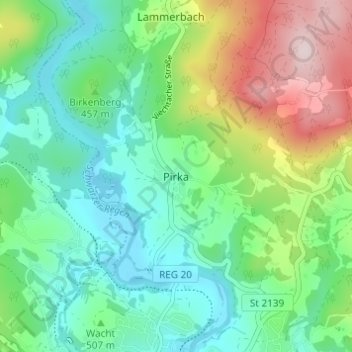
Name: Pirka topographic map, elevation, terrain.
Location: Pirka, Viechtach, Landkreis Regen, Bayern, 94234, Deutschland (49.08356 12.86748 49.12356 12.90748)
Average elevation: 516 m
Minimum elevation: 398 m
Maximum elevation: 785 m
Make a donation
Gear up for your next adventure:
As an Amazon Associate, this site earns from qualifying purchases at no extra cost to you.
Other topographic maps
Click on a map to view its topography, its elevation and its terrain.
Höllensteinsee
Deutschland > Bayern > Viechtach > Pirka > Rugenmühle
Das Einzugsgebiet ist ein waldreiches Mittelgebirge (70 % Waldbestand) und weist zwischen dem Großen Arber (1456 m) und Viechtach einen Höhenunterschied von rund 1000 Metern auf. Der Untergrund besteht aus Granit und Gneis. Die Einzugsgebietsgröße beträgt bis zur Talsperre Höllenstein 981 km² und bis…
Average elevation: 483 m