
Make a donation
Gear up for your next adventure:
As an Amazon Associate, this site earns from qualifying purchases at no extra cost to you.
Pissen topographic map
Click on the map to display elevation.
Make a donation
Gear up for your next adventure:
As an Amazon Associate, this site earns from qualifying purchases at no extra cost to you.
About this map
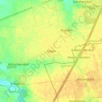
Name: Pissen topographic map, elevation, terrain.
Location: Pissen, Leuna, Saalekreis, Sachsen-Anhalt, Deutschland (51.30524 12.13212 51.34524 12.17212)
Average elevation: 113 m
Minimum elevation: 96 m
Maximum elevation: 122 m
Make a donation
Gear up for your next adventure:
As an Amazon Associate, this site earns from qualifying purchases at no extra cost to you.
Other topographic maps
Click on a map to view its topography, its elevation and its terrain.
Zöschen
Deutschland > Sachsen-Anhalt > Saalekreis > Leuna
Ein kultureller Höhepunkt im dörflichen Leben ist das jährliche „Kuchenessen“ (14 Tage nach Pfingsten), ein Heimat- und Volksfest, welches seit Jahrhunderten stattfindet.
Average elevation: 97 m