
Make a donation
Gear up for your next adventure:
As an Amazon Associate, this site earns from qualifying purchases at no extra cost to you.
Mepral topographic map
Click on the map to display elevation.
Make a donation
Gear up for your next adventure:
As an Amazon Associate, this site earns from qualifying purchases at no extra cost to you.
About this map
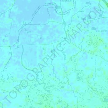
Name: Mepral topographic map, elevation, terrain.
Location: Mepral, Thiruvalla, Pathanamthitta District, Kerala, India (9.39644 76.53129 9.41693 76.54116)
Average elevation: 2 m
Minimum elevation: -3 m
Maximum elevation: 6 m
Make a donation
Gear up for your next adventure:
As an Amazon Associate, this site earns from qualifying purchases at no extra cost to you.
Other topographic maps
Click on a map to view its topography, its elevation and its terrain.
Thiruvalla
India > Kerala > Thiruvalla
Thiruvalla lies at an altitude of 14 meters above sea level, along the north bank of the Manimala river. Thiruvalla is criss-crossed by many natural canals (known as "thodu" in Malayalam) like Chanthathodu and Manippuzha.
Average elevation: 10 m
Make a donation
Gear up for your next adventure:
As an Amazon Associate, this site earns from qualifying purchases at no extra cost to you.