
Taree topographic map
Click on the map to display elevation.
About this map
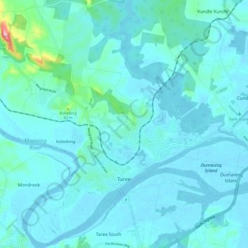
Name: Taree topographic map, elevation, terrain.
Location: Taree, Mid-Coast Council, New South Wales, 2430, Australia (-31.93833 152.39938 -31.84501 152.51154)
Average elevation: 17 m
Minimum elevation: -4 m
Maximum elevation: 185 m
Other topographic maps
Click on a map to view its topography, its elevation and its terrain.
Blue Mountains
A sandstone plateau dominated by a landscape of eucalyptus forests, the Blue Mountains are located at the top of a 470-million-year-old quartzite. In the Permian period, a shallow sea covered the region, when rivers brought shales, siltstones and mudstones. Then during the Mesozoic period, rivers dumped vast…
Average elevation: 566 m