
Tillamook County topographic map
Interactive map
Click on the map to display elevation.
About this map
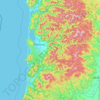
Name: Tillamook County topographic map, elevation, terrain.
Location: Tillamook County, Oregon, United States (45.04442 -124.09575 45.78360 -123.29927)
Average elevation: 236 m
Minimum elevation: -3 m
Maximum elevation: 1,073 m
According to the United States Census Bureau, the county has a total area of 1,333 square miles (3,450 km2), of which 1,103 square miles (2,860 km2) is land and 230 square miles (600 km2) (17%) is water. At 3,706 feet (1,130 m) in elevation, Rogers Peak is the highest point in the county and the highest in the Northern Oregon Coast Range.
Other topographic maps
Click on a map to view its topography, its elevation and its terrain.
Corvallis
United States > Oregon > Benton County
Corvallis, Benton County, Oregon, United States
Average elevation: 81 m
Portland
United States > Oregon > Multnomah County
Portland, Multnomah County, Oregon, United States
Average elevation: 77 m
Jefferson County
Jefferson County, Oregon, United States
Average elevation: 1,063 m
Beaverton
United States > Oregon > Washington County
Beaverton, Washington County, Oregon, United States
Average elevation: 106 m
Brookings
United States > Oregon > Curry County
Brookings, Curry County, Oregon, 97415, United States
Average elevation: 131 m
Damascus
United States > Oregon > Clackamas County
Damascus, Clackamas County, Oregon, 97089, United States
Average elevation: 163 m
Gresham
United States > Oregon > Multnomah County
Gresham, Multnomah County, Oregon, United States
Average elevation: 90 m
Woodburn
United States > Oregon > Marion County > Woodburn
Woodburn, Marion County, Oregon, 97071, United States
Average elevation: 55 m
West Linn
United States > Oregon > West Linn
West Linn, Clackamas County, Oregon, 97068, United States
Average elevation: 74 m
Deschutes County
Deschutes County, Oregon, United States
Average elevation: 1,324 m