
Make a donation
Gear up for your next adventure:
As an Amazon Associate, this site earns from qualifying purchases at no extra cost to you.
Bajaur District topographic map
Click on the map to display elevation.
Make a donation
Gear up for your next adventure:
As an Amazon Associate, this site earns from qualifying purchases at no extra cost to you.
Bajaur District
Bajaur is about 45 miles (72 km) long and 20 miles (32 km) wide. It lies at a high elevation to the east of the Kunar Valley of Afghanistan from which it is separated by a continuous line of rugged frontier hills. The old road from Afghanistan's Kabul to Pakistan went through Bajaur before a new pass, Khyber Pass, was constructed.
Make a donation
Gear up for your next adventure:
As an Amazon Associate, this site earns from qualifying purchases at no extra cost to you.
About this map
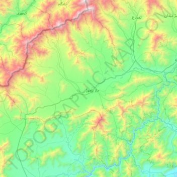
Name: Bajaur District topographic map, elevation, terrain.
Average elevation: 1,172 m
Minimum elevation: 470 m
Maximum elevation: 3,202 m
Make a donation
Gear up for your next adventure:
As an Amazon Associate, this site earns from qualifying purchases at no extra cost to you.
Other topographic maps
Click on a map to view its topography, its elevation and its terrain.