
Make a donation
Gear up for your next adventure:
As an Amazon Associate, this site earns from qualifying purchases at no extra cost to you.
Shafter topographic map
Click on the map to display elevation.
Make a donation
Gear up for your next adventure:
As an Amazon Associate, this site earns from qualifying purchases at no extra cost to you.
About this map
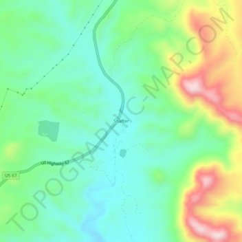
Name: Shafter topographic map, elevation, terrain.
Location: Shafter, Presidio County, Texas, United States (29.79736 -104.32613 29.83736 -104.28613)
Average elevation: 1,256 m
Minimum elevation: 1,131 m
Maximum elevation: 1,524 m
Make a donation
Gear up for your next adventure:
As an Amazon Associate, this site earns from qualifying purchases at no extra cost to you.
Other topographic maps
Click on a map to view its topography, its elevation and its terrain.
Chinati Mountains State Natural Area
United States > Texas > Presidio County
Average elevation: 1,241 m
Marfa
United States > Texas > Presidio County
Marfa experiences a semi-arid climate (BSk) with hot summers and cool winters. Due to its elevation and aridity, the diurnal temperature variation is substantial.
Average elevation: 1,434 m
Marfa
United States > Texas > Presidio County
Marfa experiences a semi-arid climate (BSk) with hot summers and cool winters. Due to its elevation and aridity, the diurnal temperature variation is substantial.
Average elevation: 1,434 m
Make a donation
Gear up for your next adventure:
As an Amazon Associate, this site earns from qualifying purchases at no extra cost to you.