
Make a donation
Gear up for your next adventure:
As an Amazon Associate, this site earns from qualifying purchases at no extra cost to you.
Mallnitz topographic map
Click on the map to display elevation.
Make a donation
Gear up for your next adventure:
As an Amazon Associate, this site earns from qualifying purchases at no extra cost to you.
About this map
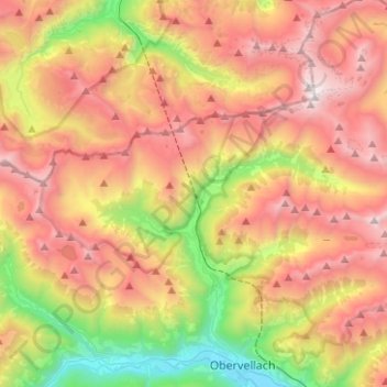
Name: Mallnitz topographic map, elevation, terrain.
Location: Mallnitz, Bezirk Spittal an der Drau, Carinthia, 9822, Austria (46.96665 13.07000 47.05058 13.32043)
Average elevation: 1,926 m
Minimum elevation: 662 m
Maximum elevation: 3,193 m
Make a donation
Gear up for your next adventure:
As an Amazon Associate, this site earns from qualifying purchases at no extra cost to you.
Other topographic maps
Click on a map to view its topography, its elevation and its terrain.
Seebach
Austria > Carinthia > Bezirk Spittal an der Drau > Seeboden am Millstätter See
Average elevation: 654 m
Innerkrems
Austria > Carinthia > Bezirk Spittal an der Drau > Krems in Kärnten
Average elevation: 1,811 m
Kleindombra
Austria > Carinthia > Bezirk Spittal an der Drau > Millstatt am See > Obermillstatt > Kleindombra
Average elevation: 814 m
Make a donation
Gear up for your next adventure:
As an Amazon Associate, this site earns from qualifying purchases at no extra cost to you.
Schmelzhütten
Austria > Carinthia > Bezirk Spittal an der Drau > Flattachberg > Schmelzhütten
Average elevation: 1,118 m