
Make a donation
Gear up for your next adventure:
As an Amazon Associate, this site earns from qualifying purchases at no extra cost to you.
Oud-Valkenburg topographic map
Click on the map to display elevation.
Make a donation
Gear up for your next adventure:
As an Amazon Associate, this site earns from qualifying purchases at no extra cost to you.
Oud-Valkenburg
Oud-Valkenburg ligt in het dal van de Geul, die ten noorden van het dorp stroomt. De hoogte bedraagt ongeveer 75 meter. Vanuit het dorpje is via het voetpad en de brug over de Geul de Drie Beeldjes, het hellingbos Schaelsbergerbos en de Schaelsberg met daarop de Kluis bereikbaar. Bij de Kluis wordt jaarlijks in het bos de Sjaasbergergank georganiseerd. Ten oosten van de Kluis ligt de Daolkesberg met gele kalksteenwand. Aan de voet van de heuvel ligt de Kalkoven Schaelsberg. Aan de zuid- en zuidwestzijde liggen het Biebosch, het Sint-Jansbosch en het Gerendal.
Make a donation
Gear up for your next adventure:
As an Amazon Associate, this site earns from qualifying purchases at no extra cost to you.
About this map
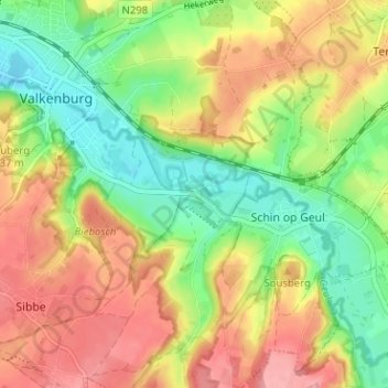
Name: Oud-Valkenburg topographic map, elevation, terrain.
Average elevation: 117 m
Minimum elevation: 67 m
Maximum elevation: 169 m
Make a donation
Gear up for your next adventure:
As an Amazon Associate, this site earns from qualifying purchases at no extra cost to you.