
Neudoerfel topographic map
Interactive map
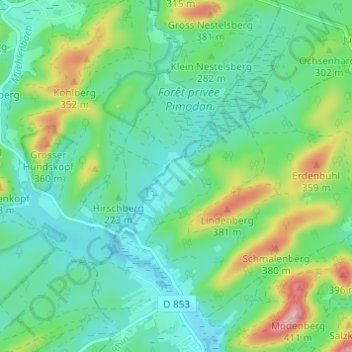
Click on the map to display elevation.
About this map
Name: Neudoerfel topographic map, elevation, terrain.
Average elevation: 271 m
Minimum elevation: 223 m
Maximum elevation: 398 m
Other topographic maps
Click on a map to view its topography, its elevation and its terrain.
Angelsberg
France > Grand Est > Bas-Rhin > Dambach
Angelsberg, Dambach, Haguenau-Wissembourg, Bas-Rhin, Grand Est, France métropolitaine, 67110, France
Average elevation: 360 m
Neunhoffen
France > Grand Est > Bas-Rhin > Dambach
Neunhoffen, Dambach, Haguenau-Wissembourg, Bas-Rhin, Grand Est, France métropolitaine, 67110, France
Average elevation: 275 m