
Andover topographic map
Interactive map
Click on the map to display elevation.
About this map
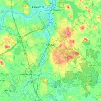
Name: Andover topographic map, elevation, terrain.
Location: Andover, Essex County, Massachusetts, United States (42.59802 -71.25619 42.70127 -71.07617)
Average elevation: 44 m
Minimum elevation: 5 m
Maximum elevation: 129 m
Other topographic maps
Click on a map to view its topography, its elevation and its terrain.
East Parish
United States > Massachusetts > Essex County > Boxford > Boxford > East Parish
Average elevation: 38 m
Mount Vernon Park
United States > Massachusetts > Essex County > Lawrence > Mount Vernon Park
Average elevation: 29 m
Amesbury
United States > Massachusetts > Essex County > Amesbury
Amesbury is located at 42°51′29″N 70°55′50″W / 42.85806°N 70.93056°W / 42.85806; -70.93056. According to the United States Census Bureau, the city has a total area of 13.7 square miles (35.5 km2), of which 12.3 square miles (31.8 km2) is land and 1.5 square miles (3.8 km2), or 10.65%, is…
Average elevation: 24 m