
Make a donation
Gear up for your next adventure:
As an Amazon Associate, this site earns from qualifying purchases at no extra cost to you.
Wolfach topographic map
Click on the map to display elevation.
Make a donation
Gear up for your next adventure:
As an Amazon Associate, this site earns from qualifying purchases at no extra cost to you.
About this map
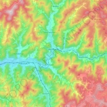
Name: Wolfach topographic map, elevation, terrain.
Average elevation: 522 m
Minimum elevation: 225 m
Maximum elevation: 946 m
Make a donation
Gear up for your next adventure:
As an Amazon Associate, this site earns from qualifying purchases at no extra cost to you.
Other topographic maps
Click on a map to view its topography, its elevation and its terrain.
Make a donation
Gear up for your next adventure:
As an Amazon Associate, this site earns from qualifying purchases at no extra cost to you.
Hornisgrinde
Duitsland > Baden-Württemberg > Ortenaukreis > Sasbachwalden
De Hornisgrinde is een berg in de deelstaat Baden-Württemberg, Duitsland. De berg heeft een hoogte van 1.163 meter en is gelegen in het Zwarte Woud.
Average elevation: 968 m