Geolocate

Bioko topographic map

Click on the map to display elevation.

About this map

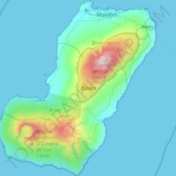
Name: Bioko topographic map, elevation, terrain.

Location: Bioko, Bioko Sur, Región Insular, Equatorial Guinea (3.20903 8.41404 3.78823 8.93812)

Average elevation: 301 m

Minimum elevation: -1 m

Maximum elevation: 2,953 m

Gear up for your next adventure:

🥾Men's Waterproof Boots - Sturdy footwear for wet and boggy Irish terrain
💧Portable Water Filters - Safe drinking water from streams and lakes
🥾Women's Waterproof Boots - Gore-Tex protection for trail and mountain walking
🧺Waterproof Picnic Blankets - Dry seating for breaks on damp grass
🩹Compact First Aid Kits - Treat blisters and minor injuries on the trail

As an Amazon Associate, this site earns from qualifying purchases at no extra cost to you.