
Thank you for supporting this site ❤️
Make a donation
Make a donation
Gear up for your next adventure:
As an Amazon Associate, this site earns from qualifying purchases at no extra cost to you.
Highland topographic map
Click on the map to display elevation.
Thank you for supporting this site ❤️
Make a donation
Make a donation
Gear up for your next adventure:
As an Amazon Associate, this site earns from qualifying purchases at no extra cost to you.
About this map
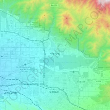
Name: Highland topographic map, elevation, terrain.
Location: Highland, San Bernardino County, California, United States (34.07691 -117.26106 34.14274 -117.06336)
Average elevation: 601 m
Minimum elevation: 303 m
Maximum elevation: 1,994 m
Thank you for supporting this site ❤️
Make a donation
Make a donation
Gear up for your next adventure:
As an Amazon Associate, this site earns from qualifying purchases at no extra cost to you.
Other topographic maps
Click on a map to view its topography, its elevation and its terrain.
Serrano Village
United States > California > San Bernardino County > San Bernardino
Average elevation: 489 m