
Make a donation
Gear up for your next adventure:
As an Amazon Associate, this site earns from qualifying purchases at no extra cost to you.
Saint-Joseph topographic map
Click on the map to display elevation.
Make a donation
Gear up for your next adventure:
As an Amazon Associate, this site earns from qualifying purchases at no extra cost to you.
About this map
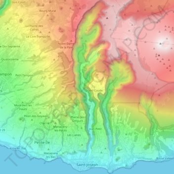
Name: Saint-Joseph topographic map, elevation, terrain.
Location: Saint-Joseph, Saint-Pierre, La Réunion, 97480, France (-21.38971 55.58213 -21.19437 55.70566)
Average elevation: 1,061 m
Minimum elevation: 0 m
Maximum elevation: 2,619 m
Make a donation
Gear up for your next adventure:
As an Amazon Associate, this site earns from qualifying purchases at no extra cost to you.
Other topographic maps
Click on a map to view its topography, its elevation and its terrain.
Le Guillaume
France > La Réunion > Saint-Paul
Le Guillaume, aussi appelé Le Guillaume Saint-Paul, est un lit-dit de l'Île de La Réunion, département d'outre-mer français situé dans le sud-ouest de l'Océan Indien. Perché à 900 mètres d’altitude, il fait partie de la commune de Saint-Paul et son code postal est le 97423.
Average elevation: 614 m
Make a donation
Gear up for your next adventure:
As an Amazon Associate, this site earns from qualifying purchases at no extra cost to you.