
Make a donation
Gear up for your next adventure:
As an Amazon Associate, this site earns from qualifying purchases at no extra cost to you.
Tiefenbach topographic map
Click on the map to display elevation.
Make a donation
Gear up for your next adventure:
As an Amazon Associate, this site earns from qualifying purchases at no extra cost to you.
About this map
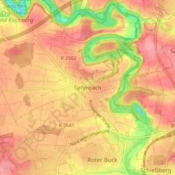
Name: Tiefenbach topographic map, elevation, terrain.
Average elevation: 424 m
Minimum elevation: 366 m
Maximum elevation: 452 m
Make a donation
Gear up for your next adventure:
As an Amazon Associate, this site earns from qualifying purchases at no extra cost to you.
Other topographic maps
Click on a map to view its topography, its elevation and its terrain.
Jagstheim
Deutschland > Baden-Württemberg > Landkreis Schwäbisch Hall > Crailsheim
Average elevation: 429 m
Goldbach
Deutschland > Baden-Württemberg > Landkreis Schwäbisch Hall > Crailsheim
Goldbach liegt am Fuße des bewaldeten Höhenzuges der Crailsheimer Hardt, ca. 4 km östlich vom Stadtzentrum Crailsheim entfernt. Neben dem Dorf Goldbach gehören keine weiteren Wohnplätze zum Stadtteil. Auf dem Gebiet der Gemarkung befindet sich der Burgstall der abgegangenen Burg Schönebürg.
Average elevation: 483 m
74564
Deutschland > Baden-Württemberg > Landkreis Schwäbisch Hall > Crailsheim
Average elevation: 422 m
Roßfeld
Deutschland > Baden-Württemberg > Landkreis Schwäbisch Hall > Crailsheim
Average elevation: 432 m
Make a donation
Gear up for your next adventure:
As an Amazon Associate, this site earns from qualifying purchases at no extra cost to you.