
Alcona County topographic map
Interactive map
Click on the map to display elevation.
About this map
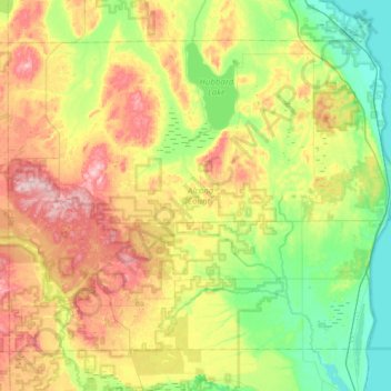
Name: Alcona County topographic map, elevation, terrain.
Location: Alcona County, Michigan, USA (44.50880 -83.88924 44.85953 -83.26956)
Average elevation: 249 m
Minimum elevation: 172 m
Maximum elevation: 384 m
Other topographic maps
Click on a map to view its topography, its elevation and its terrain.
Harold Cross Park
Harold Cross Park, 8134, Detroit, Wayne County, Michigan, 48204, USA
Average elevation: 187 m
Isle Royale National Park
Isle Royale National Park, Greenstone Ridge Trail, Houghton Township, Keweenaw County, Michigan, USA
Average elevation: 189 m