
Make a donation
Gear up for your next adventure:
As an Amazon Associate, this site earns from qualifying purchases at no extra cost to you.
Ampthill topographic map
Click on the map to display elevation.
Make a donation
Gear up for your next adventure:
As an Amazon Associate, this site earns from qualifying purchases at no extra cost to you.
About this map
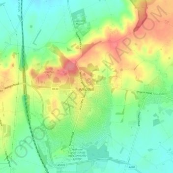
Name: Ampthill topographic map, elevation, terrain.
Location: Ampthill, Central Bedfordshire, England, United Kingdom (52.01602 -0.51835 52.04883 -0.46137)
Average elevation: 85 m
Minimum elevation: 53 m
Maximum elevation: 129 m
Make a donation
Gear up for your next adventure:
As an Amazon Associate, this site earns from qualifying purchases at no extra cost to you.
Other topographic maps
Click on a map to view its topography, its elevation and its terrain.
Little Billington
United Kingdom > England > Central Bedfordshire > Great Billington > Little Billington
Average elevation: 92 m
Make a donation
Gear up for your next adventure:
As an Amazon Associate, this site earns from qualifying purchases at no extra cost to you.