
Valdes Peninsula topographic map
Interactive map
Click on the map to display elevation.
About this map
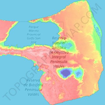
Name: Valdes Peninsula topographic map, elevation, terrain.
Location: Valdes Peninsula, Chubut, SIN DATO, Argentina (-42.87900 -64.62156 -42.07170 -63.58324)
Average elevation: 28 m
Minimum elevation: -43 m
Maximum elevation: 106 m
Most of the peninsula is barren land with some salt lakes. The largest of these lakes is at an elevation of about 40 m below sea level (see extremes on Earth), until recently thought to be the lowest elevation in Argentina and South America (the lowest point actually being Laguna del Carbón, Argentina).